CRUISE NAME:MTPII-MATER/M1CH-MAR97 IDENTIFIER: GN36199704602 Ship Name: R/V AEGAEO Call Sign: SXYY Ship Type: Research Ship PROJECT: MASTIII-MTPII-MATER Scientific Coordinating Body: NCMR |
Chief Scientist(s) :
| A) : Dr V. Lykousis | B) : Dr C. Anagnostou | C) : Dr A. Tselepides |
| Laboratory : NCMR, Inst. of Oceanography |
Laboratory : NCMR, Inst. of Oceanography |
Laboratory : Institute of Marine Biology of Crete (IMBC) |
| Address : 14, Fleming-Vari-16672, Greece |
Address : 14, Fleming-Vari-16672, Greece |
Address : P.O. Box 2214, 71003 Iraklion, Crete Greece |
| Tel : ++30 1 9656046 | Tel : ++30 1 9656046 | Tel : ++30 81 242022 |
| Fax : ++30 1 9653522 | Fax : ++30 1 9653522 | Fax : ++30 81 241882 |
| Email : vlikou@fl.ncmr.gr | Email : chanag@fl.ncmr.gr | Email : ttse@imbc.gr |
Other Participating Bodies :
D) Dr B. Price, UEDIN, UKObjectives :
The main purposes of the cruise in the frame of MATER-WP4 project were to carry out an hydrological, chemical / sea water and geochemical survey in the study area and to deploy 5 moorings equiped with sediment traps and current meters.
Additionally, this was the first cruise of the project MATER that concentrated on the study of the benthic environment at selected stations in the South and North Aegean Sea.
The main tasks involved:
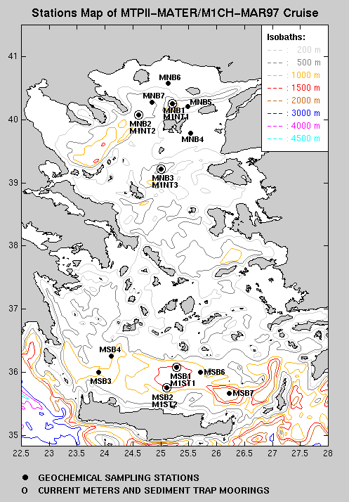
- collecting sediment samples with an 0.1 m2 USNEL Boxcorer and/or a Bowers/Connely multicorer from 5 stations in the South (MSB1, 3, 4, 6, 7) and 7 stations in the North Aegean Sea (MNB1, 2, 3, 4, 5, 6, 7) to determine:
Cruise Period Start : 12 March 1997 End : 25 March 1997
Port of Departure : Heraklion-Crete Port of Return : Limnos
SEA/OCEAN : Coded Region : D33 Local Name : AEGEAN SEA
Geographical Limits
| North : | N40 34.70 | South : N35 40.00 | ||
| West : | E024 06.00 | East : E026 13.00 |
Description of the field observations :
| STATION | DATE | TIME GMT | LATITUDE | LONGITUDE | TYPE CODE (ROSCOP) |
|---|---|---|---|---|---|
DISCIPLINES
| CODE | DISCIPLINES |
|---|---|
IOC MEDITERRANEAN REGIONS
| IOC REGION | CODE |
|---|---|
| CODE | PARAMETER | MEASUREMENT DESCRIPTION | Nb Obs. | Scientist | |||||||||||||||||||||||||||||||||||||||||||||||||||||||
|---|---|---|---|---|---|---|---|---|---|---|---|---|---|---|---|---|---|---|---|---|---|---|---|---|---|---|---|---|---|---|---|---|---|---|---|---|---|---|---|---|---|---|---|---|---|---|---|---|---|---|---|---|---|---|---|---|---|---|---|
| B02 | Phytoplankton pigments | Sediment cores were sliced in 5 depth layers (0-3, 3-10, 10-20, 20-40, 40-60 mm) and stored at -20oC for later analyses of Chla and phaeopigment concentrations | |||||||||||||||||||||||||||||||||||||||||||||||||||||||||
| B16 | Benthic bacteria/micro-organisms | Sediment cores were sliced in 3 depth layers (0-2, 2-4, 4-6 cm), processed and analysed immediately on board to determine proteolytic and respiration rates. Samples were also preserved for later determination of bacterial abundance | |||||||||||||||||||||||||||||||||||||||||||||||||||||||||
| B18 | Zoobenthos | a. Sediment cores were sliced in 4 depth layers (0-1, 1-2, 2-4, 4-6 cm) and preserved for later analysis of the benthic meiofauna | |||||||||||||||||||||||||||||||||||||||||||||||||||||||||
| b. Sediment cores were sliced in 3 depth layers (0-5, 5-10, 10-20 cm), sieved over a 0.5mm mesh and preserved in formalin for later analysis of the benthic macrofauna | |||||||||||||||||||||||||||||||||||||||||||||||||||||||||||
| B72 | Biochemical meas. | Sediment cores were sliced in 5 depth layers (0-3, 3-10, 10-20, 20-40, 40-60 mm) and stored at -20oC for later analyses of LOM (carbohydrates, lipids, proteins) | |||||||||||||||||||||||||||||||||||||||||||||||||||||||||
| B73 | Sediment traps | 5 fixed moorings for particles flux measurements | |||||||||||||||||||||||||||||||||||||||||||||||||||||||||
| D01 | Current meters | 5 fixed moorings | |||||||||||||||||||||||||||||||||||||||||||||||||||||||||
| D71 | Current profiler (eg ADCP) | In situ measurements of current speed and direction | |||||||||||||||||||||||||||||||||||||||||||||||||||||||||
| G04 | Core soft bottom | A BOWERS/CONNELY multicorer (a) and a 0.1m2 USNEL boxcorer (b) were used to collect sediment samples for the parameters: B02, B16, B18, B72, G90, H75 | |||||||||||||||||||||||||||||||||||||||||||||||||||||||||
| G90 | Other geological/geophysical meas. | a. Direct measurements of the thickness of the oxidized layer were undertaken in order to distinguish between regions of sedimentation and accumulation | |||||||||||||||||||||||||||||||||||||||||||||||||||||||||
| b. Sediment cores were opened, photographed, subsampled and stored for later measurements of grain size and determination of minerals | |||||||||||||||||||||||||||||||||||||||||||||||||||||||||||
| H09 | Water bottle stations | Water samples were collected from various depths with Niskin water bottles during CTD casts for the analyses of particulate and dissolved heavy metals (H90) | | H10 | CTD stations | In situ measurements of pressure, temperature, salinity, dissolved oxygen, light transmission | H22 | Phosphate | Near bottom water was collected from the multi-corer and stored at -20oC until further analyses of phosphate | H24 | Nitrate | Near bottom water was collected from the multi-corer and stored at -20oC until further analyses of nitrate | H25 | Nitrite | Near bottom water was collected from the multi-corer and stored at -20oC until further analyses of nitrite | H26 | Silicate | Near bottom water was collected from the multi-corer and stored at -20oC until further analyses of silicate | H75 | Total - N | Sediment cores were sliced in 5 depth layers (0-3, 3-10, 10-20, 20-40, 40-60 mm) and stored at -20oC for later analyses of TON and TOC | H76 | Ammonia | Near bottom water was collected from the multi-corer and stored at -20oC until further analyses of ammonia | H90 | Other chemical oceanographic meas. | Water samples from various depths were analysed for particulate and dissolved heavy metals | P01 | Suspended matter | | P02 | Trace metals | | P05 | Other dissolved substances | | |